General Santos
| General Santos City Lungsod ng Heneral Santos Dakbayan sa Heneral Santos |
|||
|---|---|---|---|
| — Highly-Urbanized City — | |||
 |
|||
|
|||
| Nickname(s): Tuna Capital of the Philippines | |||
| Motto: Magandang GenSan | |||
 |
|||
 General Santos City
|
|||
| Coordinates: | |||
| Country | |||
| Region | SOCCSKSARGEN (Region XII) | ||
| Province | South Cotabato | ||
| Districts | 1st District of South Cotabato | ||
| Barangays | 26 | ||
| Incorporated (town) | 1948 | ||
| Incorporated (city) | 1968 | ||
| Government | |||
| - Mayor | Darlene Antonino-Custodio(2010-2013) | ||
| - Vice Mayor | Shirlyn Bañas-Nograles (2010-2013) | ||
| - District Representative | Pedro Acharon Jr.(2010-2013) | ||
| Area | |||
| - Total | 492.86 km2 (190.3 sq mi) | ||
| Elevation | 15.0 m (49 ft) | ||
| Population (2007) | |||
| - Total | 529,542 | ||
| - Density | 1,074.43/km2 (2,782.8/sq mi) | ||
| Time zone | PST (UTC+8) | ||
| Area code(s) | 83 | ||
| Website | GenSan Local Govt Site GenSan News Online Mag www.gensanexchange.com | ||
The City of General Santos [1] (abbreviated G.S.C. or Gensan.; Cebuano: Dakbayan sa Heneral Santos, Filipino: Lungsod ng Heneral Santos) is a city in the Philippines, situated in the southern part of the country, in the province of South Cotabato. The city has a population of 535,747 as of 2007, making it one of the populous cities in the Philippines.
General Santos City is bounded by three municipalities of Sarangani Province and two municipalities of South Cotabato, namely Alabel, Malungon, Maasim, Polomolok and T'boli. The city's economy is primarily agro-industrial. As a component of the SOCCSKSARGEN growth area, it has contributed much to the area's emergence as the country's leading producer of major commodities. Due to its rich soil, good rainfall and typhoon-free climate, the area is the largest producer of corn, coconuts, copra, pineapples, asparagus and rice. The area also produces other high value crops such as exotic fruits, potatoes, vegetables, cut flowers and okra. It accounts for the largest daily total of fish landings in the country and is the leading producer of sashimi grade tuna. Residents boast that fish and seafood do not come fresher than in their city.
The city is a three time awardee for the "Most Competitive City" in the Philippines for the years 1999-2000 (all cities category) 2000-2001 (mid-sized category) and 2007 (mid-sized category)
Contents |
History
On February 27, 1939, General Paulino Santos led the first and largest batch of settlers organized under the National Land Settlement Administration to the shores of Sarangani Bay. The 62 pioneers, who mostly came from Luzon, industriously tilled Cotabato's fertile expanse of land. After this first influx of pioneers, thousands more from Luzon and Visayas migrated into the area. This started the displacement of some of the native B'laan to the mountains and lost their livelihood. The B'laan people are the original settlers of the area once called Dadiangas for thousands of years. They live in a nomadic system in the area, where the names of the places are still recalled. One name is Dadiangas, the native word name of the tree specifically grown in the area. Under Indigenous Peoples Right Act IPRA law RA 8371, now they were protected and it is proven under the Philippine jurisprudence of the Supreme Court. Now the B'laan people live side by side and with harmony to the settlers and other immigrants from small islands in Visayas and Luzon.
In January 1948, by virtue of Republic Act No. 82, Buayan District became a full-fledged municipality whose territorial boundaries included the present municipalities of Sarangani and South Cotabato Provinces, namely Alabel, Glan, Malapatan, Malungon and Polomolok. NLSA Hospital Administrator Irineo I. Santiago became its first mayor.
Six years later, in June 1954, the Municipality of Buayan was renamed General Santos as a tribute to its great pioneer. This was made possible by Republic Act No. 1107 authored by Congressman Luminog Mangelen of Cotabato Province.
From 1963 to 1967, during the incumbency of Mayor Lucio A. Velayo, an upsurge in the municipality's economy was experienced as several large agri-based corporations such as Dole Philippines, General Milling Corporation and UDAGRI expanded into the area. Although it was then qualified to become a fourth class city, the residents rejected a move by Congressman Salipada Pendatun to convert General Santos into a city and to rename it Rajah Buayan.
Finally, on July 8, 1968, upon approval of Republic Act No. 5412, which was authored by then late Congressman James L. Chiongbian, the Municipality of General Santos was converted into a city while keeping its name. It was inaugurated on September 5 of that year. Antonio C. Acharon became its first city mayor. In 1988, two decades after its inauguration, it was declared as a highly urbanized city.
Geography
Location
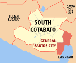
General Santos City lies at the southern part of the Philippines. It is located at 6°7'N 125°10'E. The city is southeast of Manila, southeast of Cebu and southwest of Davao.
Barangays
General Santos City is politically subdivided into 26 barangays.
- Apopong
- Baluan
- Batomelong
- Buayan
- Bula
- Calumpang
- City Heights
- Conel
- Dadiangas East (Pob.)
- Dadiangas North
- Dadiangas South
- Dadiangas West
- Fatima
- Katangawan
- Labangal
- Lagao (1st & 3rd)
- Ligaya
- Mabuhay
- Olympog
- San Isidro (Lagao 2nd)
- San Jose
- Siguel
- Sinawal
- Tambler
- Tinagacan
- Upper Labay
Accessibility

The city serves as the inbound destination for the sights, sounds and culture of SOCCSKSARGEN. Air, sea and land transport provides easy access to the key cities in the Philippines. The city is base to the Philippines' second largest airport-in-area and has one of the most modern seaports in the country.
- Air
The General Santos International Airport is the largest Airport in Mindanao., It has a 3,227-meter runway capable of handling wide-bodied jets like Airbus 340 and Boeing 747. This puts almost all key cities in the Philippines. It currently handles direct flights to Manila and Cebu through Philippine Airlines and Cebu Pacific.
- Sea
The Makar Wharf is considered one of the best in the country. With a 740-meter docking length and a 19-meter width, the wharf connects the City to destinations within and outside the Philippines. Negros Navigation, WG&A and Sulpicio Lines provide the route while Indonesian shipping lines contribute their GenSan-Indonesian route for passenger and cargo traffic.
- Land
Inbound and around SOCCSKSARGEN land travel is a fast and convenient ride. With more than 400 passenger buses and jeepneys wielding routes within, to and from the growth region, getting to your place of destination is a comfort. Laoag-General Santos route soon available via Manila by Partas operator owned by Ilocos Sur Gov. Luis "Chavit" Singson. Tricycles - three wheeled motorcycles with side-cars, are the City's main mode of land transportation and has been in the road since the pioneering times. Air-conditioned taxis and rent-a-cars are also readily available. The Pan-Philippine Highway links GenSan to other Major cities in Mindanao and to the rest of the philippines.
Infrastructure and Economy
The presence of major economic infrastructure support facilities provide the city an edge in terms of comparative advantage due to its standards that are comparable to international benchmarks.
Industry
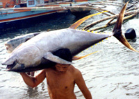
The world class Fishport Complex has a 750-meter quay, 300-meter wharf for 2,000 GT reefer carriers, refrigeration facilities with 1,500 cold storage capacity, 60 tons/day ice plant, brine, air blast and contact freezers.
Resources
- Power
Abundant power supply provided by SOCOTECO II retailer of The National Power Corporation.
- Water
Clean and safe water supply provided by GSC Water District. Baranagay Water And Sanitation
Communication
Modern and digital communication offered by major telecommunication companies. The availability of Internet Service Providers serve also as major key to be top of the domestic and international businesses.
Business
There are 59 banks operating in the city composed of 46 commercial banks, 5 savings banks, 1 cooperative and 7 rural banks in 2000. Aside from this, there are 49 pawnshops providing emergency loan assistance and 48 lending institutions.
General Santos City registered 1,505 new medium to large enterprises in 2000. Aggregate investment involved is estimated to be around P 1.899 billion, generating 4,361 new employees. Of the total investments, 76.03% were for social and personal services, 9.77% in wholesale/retail trade business, 4.38% were in manufacturing while the least at 0.02% were invested in mining & quarrying.
Education
General Santos City is the center of education of Region XII. The city houses 2 universities namely Mindanao State University - General Santos (MSU-GSC) and Notre Dame of Dadiangas University (NDDU). The largest Universities in General Santos City.
Tourism
Down the southern tip of Mindanao, expanding from the basin of Sarangani Bay, lies the City of General Santos - a fortress of modern amenities that is endowed with the beauty of nature and diverse cultures abound. Is a gateway in discovering the boundless beauty of SOCCSKSARGEN Growth Region.
Food
The Tuna City pampers its guest with tons and tons of TUNA and other fish delights that gave birth to several eating institutions. Wide range of dining establishments pop-up right into the heart of the city which can fill your cravings with satisfaction beyond capacity with a variety of Mindanaoan, Filipino, Asian and Western delicacies. Fresh-from-the-catch seafood and right-from-the-harvest agricultural products have perfectly matched to make a savory and sumptuous array of dishes in its various food outlets and restaurants.
Topping the list of must-eats are TUNA and OPAH("Dayana"), two of the best sellers among local celebrities, which come served as the exciting SUTUKIL:SUGBA (Charcoal-boiled in special sauce, dipped in the requisite Toyomansi), TULA (Soup in ginger, onion, lemon grass, pechay and tomatoes), and KINILAW (Fresh cuts in vinegar, shallots, cucumber and pepper).
Festivals

General Santos City celebrates Kalilangan Festival every February 'Kalilangan' means festival, festivity or jubilee. It is a social gathering marked by exchanging of amenities among traditional leaders, elders, allies and subordinates in varying tones. In a broader perspective, Kalilang projects a positive and dynamic meaning for it engulfs the artistic, humane and altruistic aspects of social interaction that takes place in any occasion or celebration. Kalilangan is a noble tradition. It is a complete work of art nourished and nurtured by rich cultural heritage that has withstand the test of time from generation to generation.
It is also a pageantry of unique and colorful ethnic rites, rituals and traditions like marriage celebrations, religious ceremonies, anniversaries, funerals, enthronement of royal dignitaries, thanksgiving and other forms of social, political and economic activities.
It is not just an economic activity, but a continuous season of merriment, gaiety and merrymaking accentuated by sharing of gifts, traditional sports competition, dancing, singing and instrumental rendition and other forms of exhibition games, entertainment and amusement.
Every September a part of the charter celebration. General Santos City is known as the Tuna Capital of the Philippines. Thanksgiving and festivities are being celebrated annually through its Tuna Festival. Focusing on its main industries. Tuna Float is an awesome event to taste also sumptuous tuna treats during the Tuna Culinary Contest.
The city of General Santos proposed to be set in a metropolitan status due to income and population.
Kalaja Eco-tourism Destination
Located 15 km at the North East side of General Santos City, at Barangay Conel, Kalaja Karsts Land derived her name from “Kalaha” or frying pot due to the surrounding towers of karsts formation made millions of years ago. It produced waterfalls and caves. Opposite to this area were the Ranch (camping ground) of Nopol Hills which borders Conel and Brgy. Mabuhay. The place offers wide view of Gensan, Sarangani Bay and some parts of South Cotabato and Sarangani Province.
During World War II, Gen. Santos City become one of the last frontiers between the American, Filipino and Japanese forces. Japanese retreating forces made Kalaja Karsts Land as their last ground for defenses, constructing round cemented bunkers and tunnels. Today, one can still see bunkers at Sitio Guadalupe but unfortunately for the tunnels, most were deformed and even destroyed by treasure hunters and land developers.
Sister cities
 Butuan City, Philippines
 Cebu City, Philippines
 Marikina City, Philippines
 Naga City, Philippines
 Quezon City, Philippines
 Monterrey, Mexico
 Plano, Texas, USA
References
 |
Polomolok |  |
||
| T'boli | Alabel, Sarangani | |||
| Maasim, Sarangani |
External links
- Moro Friends Community
- Wikitravel Entry on General Santos City
- Official Website of General Santos City
- Yaman Gensan Awards
- Philippine Standard Geographic Code
|
|||||||||||
|
|||||||||||
| Leading population centers | |||||||
|---|---|---|---|---|---|---|---|
| Rank | City | Population | Pop. Growth Rate | Region |  Metro Manila  Cebu City |
||
| 1 | Quezon City | 2,679,450 | 2.53% | National Capital Region | |||
| 2 | Manila | 1,660,714 | 0.03% | National Capital Region | |||
| 3 | Caloocan | 1,378,856 | 2.53% | National Capital Region | |||
| 4 | Davao City | 1,363,337 | 1.81% | Davao Region | |||
| 5 | Cebu City | 798,809 | 2.16% | Central Visayas | |||
| 6 | Zamboanga City | 774,407 | 3.54% | Zamboanga Peninsula | |||
| 7 | Antipolo | 633,971 | 5.22% | CALABARZON | |||
| 8 | Pasig | 617,301 | 2.29% | National Capital Region | |||
| 9 | Taguig | 613,343 | 4.07% | National Capital Region | |||
| 10 | Valenzuela | 568,928 | 2.23% | National Capital Region | |||
| based on the Philippines 2007 Census | |||||||
|
|||||
